Giro de Lilley Bottom - 30 & 40 mile Versions
GPX file of the route Giro De Lilley Bottom 30 & 40 mile version
This is a tour of the varied and undulating countryside of the eastern Chilterns and the valleys of the Mimram and Lea Rivers. The route starts from Harpenden Railway Station and heads down to and across the valley of the River Lea. It then crosses the higher ground between the rivers, ducks under the Luton Airport flightpath, and descends into ‘Lilley Bottom’ for 3 miles. This is the valley of the River Mimram, but this usually only emerges on the surface to flow south, where you join the valley road and head north where the valley is dry.
At this point the two routes diverge. The longer route, which probably doesn’t suit lightweight road bikes, takes you over the scarp and into the vale beyond before doubling back to Offley. It adds about 10 miles overall. The shorter route takes you straight to Offley. From there you have a meandering route back to Wheathampstead and then Harpenden.
Zooming In
Highlights are:
The classic chalk valley landscape of Lilley Bottom.
Emily’s Cafe in Whitwell. Famous in the Veloverse, but you might struggle to find it!
George Bernard Shaw's house with his revolving writing shed.
The stronghold of the Brythonic King Cassivellaunus at Wheathampstead
The unlikely last abode of the real villain of the notorious French Dreyfus Affair.
And more than the usual party bag of oddities.
The longer route heads on through Lilley Village, crosses the ancient Icknield Way and heads over the scarp slope and down to Hexton in the Valley. From there the route runs clockwise through flat(ish) arable country through to Pirton. The route then climbs the Pegsdon Hills to Offley.
For the short version of the route you turn right at the end of Lilley Bottom and head up the hill to Offley. From there, both routes follow the east side of the Mimram Valley, descending into Whitwell where the river is clearly visible. Emily’s Cafe is hidden from view off a short street on your left. Leaving Whitwell the route gets more complicated. You head south for 2 miles before turning right to rejoin the Mimram valley. A turn off on the right takes you past G.B. Shaw’s house and onwards to join the Ayot Greenway. This converted railway track is part of NCR57, that takes you to Wheathampstead. After a mile on the road heading west from there, you can rejoin it to complete the trip back to Harpenden.
If your app provides notes on the road surfaces etc. keep in mind that they are automatically generated and only as good as the underlying mapping.
From Pirton the route follows the Chilterns Cycleway (an NCR) initially using footpaths. On a hybrid, I manage most of it but dismount where the ruts are deepest. In winter, I divert by going straight through Pirton and turning right on the busy Hitchin Road to rejoin the route about 2 miles on. Consult the map.
Turning left off the Hitchin Road towards Offley, the route is only partly surfaced. There is no easy diversion here and, again, you might want to dismount when you encounter deep ruts. It will only be for a few hundred metres.
The Ayot Greenway is mostly hard earth and OK. Ditto the continuation of the NCR into Harpenden although that can be muddier after rain. In this case, if you consult your map you will see that you can easily avoid both if you want to stick to roads.
Zooming Out
The bedrock of the Chilterns
is chalk which comes to the surface on higher ground. The Chilterns
were spared the worst of the ravages of glaciation and there is
extensive areas of clay and gravel on the higher ground. It is those
clay ‘lenses’ on the hills that lead to the roads sometimes
flooding where you might not expect it.
In
1538 the travelling diarist John Leland
1538 described the Chiltern
Hills on his twitter feed as
'baron, woody and ferne
ground'. But the higher
ground in particular had never been particularly welcoming.
This was frontier territory
for a long time. Before the Romans showed up it was populated by the
Belgic Catuvallauni tribe whose King, Cassivellaunus, purportedly
surrendered to Julius Caeser here. Roman settlement followed as you
would expect given the proximity of St Albans, but they left nothing
to see on this route except some straight roads! Later, during Saxon
times, King Offa of the Mercians held court here and after Mercia
succumbed to the Vikings, King Alfred drew the boundary between the
Saxons and the Viking ‘Danelaw’ along the River Lea. ‘Lea’
is old English and means ‘meadow’.
Generally, the population
here was never as dense on the higher ground as it was in the lower
countryside to the north and south. The soils were poorer and water
was harder to find. In this area in particular you will find many
hamlets named with the suffix ‘End’ or ‘Green’. Many of
these occupy land carved out from woodland as ‘assarts’ in
Medieval times. The larger settlements and better farms were
concentrated in the fertile valleys and lower slopes where there was
a water supply and where the larger villages are now situated.
The villages are for the
most part pretty but not stunningly so, with a scattering of houses
great & small and pubs dating back up to 400 years and several
churches that are very much older, nearly all of which have been
altered in varying degrees.
A. Harpenden
Harpenden might be a decent sized town now but it hasn't got a long history. Batsford, the part of the town in the Lea Valley at the bottom of Station Road, was probably the original settlement. The higher ground was mainly woodland, with sporadic and piecemeal clearance for small hamlets and single farmsteads, many of which survive today, often name tagged 'End' or 'Green'.
 |
| Station Road Harpenden in the 1800's |
The river you cross leaving Harpenden is the headwaters of the Lea that later flows through East London and the Olympic Park, joining the Thames at Poplar. This is the River Lea, the same River Lea that flows through the Olympic Park and into the Thames.
It once formed the boundary between the Wessex of the King Alfred and Guthrun's Danish Vikings. The 'Treaty of Wedmore' between them, which created the 'Danelaw', apparently says: 'Concerning our land boundaries: Up the Thames and then up the Lea unto its source then straight to Bedford'. So you might keep an eye out for blond blokes with winged helmets after you cross the River.
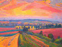
B. Lilley Bottom -The dry Mimram Valley
The Mimram created this valley in the ice ages when the ground was frozen and thus not so porous. Usually, chalk is porous, so water filters through it and rivers only exist when they flow across less permeable materiel like clay or more usually in places and at times after rain. So during a dry spell when the water table is low, the floor of the upper valley remains above it and there is no spring. But when it has been raining a long time the upper valley can also flood in places, although this rarely morphs into an extension to the river. Usually, the Mimram only emerges near Whitwell and the upper part of its valley, Lilley Bottom, is ‘dry’. For still more information on the chalk landscape and its rivers, see my blogpost on chalk landscapes.
 |
| Lilley Bottom, the dry valley of the Upper Mimram River |
D. Lilley : 53 West Street
Here is a good example of a house trying to hide its age! Don’t be fooled by the front, take a look at the walls on the Northern side. It is This is a hall from around 1500 with bits added from the medieval lego kit over the following 200 years.
Gratuitous Facts: In the 1200's the Manor was held by a knight with the glorious name of 'Pain de Chaworth'. Until 2017 the MP for Lilley’s constituency was Lilley, now Lord Peter Lilley,
 |
| 53 West Street Lilley |
E. Icknield Way
For the last hundred metres or so you have been cycling the Icknield Way This is thought by some (not all!) to consist of pathways that were already ancient when the Romans turned up and which even go back to the later Stone Age. It is clear here, but some reckon that it extended from the coast in Dorset to Norfolk. In the woods on the hill on your left and scarcely visible as you cycle towards the scarp, is Ravensburgh Castle, said to be the biggest iron age hillfort in South East England.
 |
| The Icknield Way. Painting by Spencer Gore |
F. Higham Gobion - Shrunken Village
Higham Gobion has shrunk. It is one of those places often described as plague villages. But in fact many villages simply withered because land use patterns and ownership changed, often because grazing was more profitable than smallholdings. In this case the shrunking apparently started in the 1500's. Remains of the old, larger settlement can still be seen if you look closely. I suggest you don’t bother. They are truly unimpressive.
This used to be 'Champion' countryside, a layout of villages surrounded by large common fields, that were divided into strips, allocated to individuals on a rotating basis. You can see an example in the pic below, taken from a 1771 map of nearby Ickleford. This system of farming, which pre-dated the Norman Conquest, was largely wiped out by the enclosures that in this area was in 1776 and which gave us the rectangular fields and straight roads you see today. Note the slight curves in the old strips which result from the course of the heavy ploughs..
 |
| Ickleford 1771 |
You are the blue dot in the the aerial pic. The curves of that thousand year old field pattern are reflected in some of the new field boundaries. Rectangles are neat but sometimes it was easier to simply enclose the old fields! The medieval landscape has left lots of footprints, but you usually have to squint to see them!
 |
| Higham Gobion |
You can find more on this in my posts on the evolution of our rural landscape.
Link: The Englisc Landscape
G. Pirton
At the heart of old Pirton is a mound that was once occupied by a 'castle' that was in fact little more than a timber palisade built in Norman times. It was Then Henry II pointed out that they hadn’t got planning permission so it was demolished. The mound was then used for meetings and became known as Toot Hill.
H. Yeshivas Toras Chessed
Cycling up here once, I was astonished to see some traditionally dressed young Jewish men arranging themselves in a tree here. Their outfits & headgear were not helping. In case you have the same experience, it turned out that, just to the east of the path is Wellbury House, a Yeshiva or rabbinical school for Torah study.
I. Great Offley
Legend has it that in the 8th century King Offa of Mercia (as in ‘Offa’s Dyke on the Welsh border) discovered the bones of Saint Alban and set about creating St Albans Abbey in a tribute to him. Unlike, say, King Arthur, he had a limited social media profile, so we don't know much about him for certain; but it appears that while the Abbey was being completed and no doubt with an eye on future house prices, he built an exclusive detached residence in what is now Offley. It was reputedly at the end of the small lane opposite the Red Lion at the far end of the village which then became known as Great Off Lee. This might sound unlikely, but Mercia was the principle kingdom in England at that time and Offa is supposedly buried at Bedford which isn't that far away. The village is unprepossessing but there a couple of pubs here and, a few miles further down the road here, the Kings Walden Post Office serves coffee and a few snacks when it is open.
 |
| King Offa and St Albans Cathedral |
 |
| Great Offley c. 1900 |
J. Kings Walden Bury & Deer Park
There are quite a few 'Waldens' and similar names hereabouts It has been suggested that the 'Walden' name indicates that when the Angle-Saxon settlement was underway, this was still seen as a British place, 'Wales' meaning foreigner in very old English. That seesm to have changed over time.
“.........from before the time of the Domesday Survey two manors were in existence in King's Walden. Each was estimated at 1 hide and both were owned by Earl Harold before the Norman Conquest...”
The big hoose here, Kings Walden Bury, was rebuilt in the 1960’s. I believe that the current owner of the Estate is Sir Thomas Henry Milborne-Swinnerton- Pilkington 14th Baronet Pilkington, of Stanley, near Wakefield and Nether Bradley and a descendant of Mary Tudor. You wouldn’t want that name on the back of a football shirt! I get confused by the various Tudor Mary's but understand that this one was a daughter of Henry V11 who had a brief stint as Queen of France by marriage to Louis XII.
K. Whitwell, Watercress & Boozers.
As you cycle into Whitwell you will pass Nine Wells Watercress Farm, run by the same family for some 200 years and so called because it draws on nine artesian wells sunk some 70m or so into the chalk. More generally, watercress grows in clean (and preferably flowing) water coming from springs and wells, because that is less likely to freeze in the winter. It is traditionally harvested in time to serve as a supplement to the winter diet.
Whitwell is a decent place to stop for a break and Emily's (see the introductory notes) is a popular cafe stop with outdoor eating. It is well hidden in the Water Hall Farm buildings; to find it turn down Valley Road next to an old house on the High Street called Moonrakers, which was built around 1500 as an open hall house and divided into 5 cottages by late 18th century before being restored as one house in the 1960’s.
The only pub is the 16th c. Bull. Apparently there used to be seven. An old rhyme goes:
Beware the Bull don’t toss you, boys / The Swan don't pull you in / The Maiden's Head has often led / Young people into sin / The Eagle's claws are sharp & strong / The Fox can bite you know / The little Lamb can buck and ram / The Woodman lay you low
This bears witness to the reputation that the place had for p*** artistry but not for poetry. Many of the pubs are now private houses.
On the left as you go through Whitwell, just off 'The Valley' is Emily's Tea Shop, a regular meeting spot and favoured cafe for the lyra clad hordes with outdoor seating in the old farm yard and a collection of cycling mags if you want a read with your caffeine.
 |
| Nine Wells Watercress Beds. Whitwell |
L. Ayot St Lawrence & George Bernard Shaw
If you want to see or visit 'Shaw's Corner' make a diversion into the village by keeping straight on here. I'm a fanboy. So for me, this is a pilgrimage spot.
Shaw lived here from 1906 to 1950 spending much of his later life writing in the revolving summerhouse which can still be seen in the garden of his house. (There is a modest charge to visit).
He was a master of spearing the pretensions and politics of the English bourgeoisie. Even if you are not familiar with most of his plays, you might have seen 'My Fair Lady' as a play or film. It was based on Shaw's 'Pygmalion'. Born Irish, he was described by the Irish Times as the most globally influential Irish person in history! (So, that isn't Bono then!?)
 |
| Shaw's Shed |
There are two 'St Lawrence's' Churches here. The old one was part demolished. Being the house of God counted for nothing if you spoiled the view from Sir Lionel Lyde's windows; but then he was probably a slave trader and thus dammed in any event. The replacement is a fairly silly Palladian concoction that also serves as Lionel's last resting place. He is buried on one side of it and wife on the other. They didn’t get on.
Note that the posh façade faces the Hall and hides what is otherwise a very basic building. Apparently the place is popular with satanists....
 |
| Ayot St Lawrence |
The Brocket Arms in the village is a nice pub, especially if you like ghosts; in this case an affable former monk who was hanged here.
M. Ayot Mountfitchet & Ayot St Peter’s.
The rather grand property on the west side of the road on the way to Ayot St Peter’s is Ayot Mountfitchet. You don’t really get a decent view of it from the road but can often sneak in some distance. It is Tudor era Hall complete with an 'Arts & Crafts period boathouse, a lime tree cathedral and romantic garden'.
The ‘St Peter's’church in Ayot St Peter's is mostly notable for NOT being another olde worlde job, but rather a rare example of an Arts & Crafts style building designed by J P Seddon and built in 1875. As you are no doubt aware Saint Peter’s is one of only thirteen Hertfordshire churches featured in the book “England’s Thousand Best Churches” by Simon Jenkins.
 |
| St Peter's Ayot |
N. Ayot Greenway -Cycle Route
The Greenway uses the abandoned he track of the Luton, Dunstable & Welwyn Junction railway which ran from 1860 until the 1960's when Dr. Beeching did for it. It now forms part of National Cycle Route 57. The track is rough but reasonably compacted, wide & well drained fairly solid and usable with care on a road bike in most weathers.
 |
| Nickey Line / Greenway |
O. Julius Caesar & The Defeat of the Britons
This is a very short diversion which you can easily avoid if you are not interested. The earthworks just to the east of Dyke Road here are reputedly the remains of the capital of the Belgic iron age Catuvellauni tribe and where Julius Caesar of the Roman European Union defeated the powerful chieftain Cassivellaunus on his second excursion across the Channel in 54 B.C., in a battle that effectively sealed the eventual and fairly total subjugation of the Britons in England.
Jules' was assisted by the Trinovantes tribe who were the Catuvellauni's neighbours to the East and who had scores to settle with them. One of Cassivellaunus' predecessors was Cunobelinus who was immortalised by Shakespeare as Cymbeline in his eponymous play. The indicated route takes you into Wheathampstead down Conqueror's Hill, presumably so named just to rub it in a bit.
Maybe the obsequiousness is unjustified. This was not so much a conquest as a major raid as a piece of personal brand building, than a conquest, which happened almost a century later. Like Churchill later, Caesar made sure that history was kind to him, by writing it history himself.
 |
| Cassivilaunus |
P. Wheathampstead Mill
The public open space alongside the river that you have just passed through used to be 'Lammas Land', being land that was owned but on which commoners were entitled to pasture between Lammas day (12 August) and 6 April.
The Mill buildings here date back to the 1600's .You can see the remnants of the Mill Race from the foot bridge on the left. They were refaced in brick around 120 years ago. The Bull Pub adjacent on the south side of the river dates back to the 1500's and was apparently a popular place in the 1600's when Wheathampstead was renowned for its fishing. A lot of houses in the town date back to then.
From here route takes you across the river and up to the roundabout junction with the B563 . The ‘retired’ railway station on the Welwyn line is located to the SW of the roundabout. This route joins the old track some way towards Harpenden, but first you must tolerate the traffic on the busy B563 for a mile or so before finding the cycle path on the old railway line through the woods along the River Lea.
Q. Harpenden. 140 Station Road : The Dreyfuss Affair
This is nondescript detached house on the hill on your way back up to Harpenden Station, is one of the bookends of the famous story of the fate of Captain Alfred Dreyfus, who served in the French Army at the end of the 19th century and was accused of spying for Germany. He was found guilty and imprisoned on notorious hell hole that was Devil’s Island in the Caribbean. Dreyfus was Jewish and his conviction was increasingly regarded as a ‘fix’ and biased by anti-Semitic prejudice. A campaign led by the famous writer Emile Zola, who wrote a famous letter in Dreyfus' support entitled ‘J’accuse’, eventually led to his release and pardon.
The real culprit turned out to be Charles Esterhazy a Major in the army (pictured) with a credible record but a dissolute lifestyle which resulted in heavy debts. His veneer of respectability meant that he wasn’t dealt with anywhere near as harshly as the Jewish Esterhazy and the controversy rumbled on. Eventually he fled to England to live in this unremarkable house on the right as you cycle up the hill towards the Station. The whole story with its racist and anti-Semitic overtones remains controversial in France today.


Comments
Post a Comment
You can leave a message here or email me :
mail@mickbeaman.co.uk