Posts

Showing posts from June, 2023

The High Weald

Image
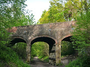
  Link to GPX File of Route   The High Weald This  is a 43 mile route through the High Weald ‘Area of Outstanding Natural Beauty’ from Crawley to the outskirts of Eastbourne which might appeal to anyone who wants an off road trail that doesn’t involve the very rough tracks beloved of the mountain bikers.  It follows National Cycle Route 21, so mapping it involved very little effort on my part,. I have eschewed waypoints simply because I am ignorant of any compelling things to look out for on the route. The attraction is simply the generously wooded countryside; ‘Weald’ comes from the old German word ‘Wald’ and means ‘Wooded’.  But the ‘High’ in the name isn’t a misnomer and there are a few climbs between miles 21 and 31 as you head south, before a gentle cruise down from the Weald towards the coast on the ‘Cuckoo Trail’ towards Polegate Station. This is one of the many trails built on railway lines cut by Beeching in the 1960's and I believe it ran from Polegate to Tunbridge Wells

Avon & Test (Overnighter)

Image
Route GPX File :    Avon & Test Valley Route This route follows three river valleys; the Avon, Dun and Test, which dissect the rolling chalk hills of the Salisbury Plain and the Berkshire Downs. It ends at Newbury which is on the same train line as Pewsey. For the most part it follows quiet roads and scattered hamlets in open countryside. Leaving Pewsey Station, the minor road along the east side of the Avon Valley connects villages that are attractive pretty without reaching chocolate box standards. Approaching Salisbury, you pass the hillfort and castle of Old Sarum, where English Heritage recommend you ‘sniff out the old latrine pits’. Lovely. But a visit is worthwhile, if only for the views. Salisbury itself is a handsome city and worth a detour. In both cases you can see (in)famous 123m tall spire of its Cathedral. Великолепный ! The pre-historic landscape of Stonehenge is only a few miles to the east. Old Sarum The route to and along the Dun is quiet and pleasant without m

Avalon (Overnighter)

Image
  GPX File of the Route.   Avalon This 70 mile route starts from Castle Carey, a small town in the low hills of South Somerset which, rather surprisingly, is a regular stop for trains on the main line from Paddington to the West Country. It is an easy ride, so there should be time for a bit of sightseeing. I like to do it clockwise to get the steepest hill out of the way early on. Accommodation at around the half way point on the route itself is sparse, but a short detour takes you into Burnham on Sea where there is plenty. Some five miles south of Castle Carey you pass Cadbury Castle, a candidate for King Arthur’s Camelot and a colossal hillfort. Really, it is worth climbing up it just to get an impression of the scale of the beast. It covers the equivalent of over ten football pitches. Keep in mind that the imposing ramparts were once even higher and the ditches deeper. The organisation and effort (if not the engineering) that it must have taken to build it in the Bronze Age stand