Highs And Lows of Cherwell
GPX File of the route: Highs & Lows of Cherwell
This is a varied but undemanding ride around the fringes of the Cotswolds in Northern Oxfordshire. It leaves Bicester using the cycle path to the South of the A41 then crosses that road to follow the Roman ‘Akeman Street’ to its conclusion. The route then heads north for 10 miles across higher ground to cross the River Cherwell at Somerton. You then climb around 200 ft, into the Eastern foothills of the Cotswolds and follow a scenic ridge road for a few miles before turning south towards Islip and the flat and empty marshland of Otmoor. Outside of Bicester, the ride uses minor and usually well-maintained roads. There are no off road sections. The living is easy, the fish are jumping etc.
Zooming In
Highlights are:
Laughing at the ersatz ‘consumer paradise’ of Bicester Shopping Village.
Enjoying the genuine character of the Cotswold stone villages, Lower Heyford, Somerton, Dun's Tew, Islip and Chalton
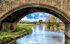
The views from the ridges above and beyond the Cherwell Valley
Islip, Birthplace of Edward The Confessor
The rather strange flat, empty, often windy and once fought over drained marshland of Otmoor
The usual melange of oddities.
Route Tips
If your app provides notes on the road surfaces etc. keep in mind that they are automatically generated and only as good as the underlying mapping. In this case the route is all on road and should present no problems. If you do the tour anti-clockwise as suggested, you will probably end up on the home straight across flat Otmoor with the wind at your back. Lovely!
Zooming Out
As you might expect, this area is mostly an extension of the limestone geology of the Cotswolds foothills. All of these limestones are rich in fossils. Keep an eye out! As usual there is a lot of clay, but equally much variety. In places you find ‘cornbrash’ or ‘stonebrash’, a dry rubble that wheat seems to like.
Under the mud in Otmoor is ‘blue shale’ mudstone (older mud!), another fine grained variety of sedimentary rock. The villages sit on islands of gravel in what used to be extensive marshes.
Eastern Oxfordshire is a wealthy area and the attractive villages hereabouts owe more to a little ‘re-imagining’ and careful maintenance than benign neglect. The farmers seem to be growing winter wheat, barley and oilseed with a lot of land left fallow and fewer sheep and cattle. It wasn't always like that. Farming on the heavy and badly drained soils of the clay vale in particular could be difficult although both pastoral and arable farming are possible. Notwithstanding, even the higher ground has been shaped by the enclosures. The exceptions are mainly the Parklands associated with the grand estates and the smallholdings flanking the road across Otmoor. There are few commons or waste lands.
The Churches and Manors around here are often have longer histories but the latter have often been substantially modified, usually by the obscenely rich, famous or notorious. The Waypoint notes cover the most egregious examples.
A. Bicester and its 'Village'
Bicester has managed to become a tourist magnet in spite of having nothing much worth seeing, and the reason is right next to you. This weird ersatz village has become a monument to post-modern consumerism, ranking as No 2 to Buckingham Palace and ahead of the British Museum as the place most visited by Chinese tourists in the UK.
 |
| Traditional Cotswold Clobber at Bicester Village |
The first 'Bicester' was probably Roman Alchester, located in the fields to the south on your way out the town. There is nothing to be seen now but some remains can be identified in old maps and have been excavated. By the 8th Century it had become 'Beorna's Fort and there was certainly some Anglo Saxon - Briton bother in these parts with the Mercian Angles winning out.
B. The Roman Road
Akeman Street linked Watling Street, the Romans version of the A5, to Cirencester. You will be cycling about 3 ft above the old surface which we know (because it was uncovered where they were building the M40) was metalled and covered with the debris dug out of flanking ditches. On the way you pass the Kirtlington Park Polo Club. Polo is perhaps to Oxfordshire what the Lancashire Mill Towns are to Rugby League, albeit with a pricier post-match pint and no pies.
 |
| The Surface of a Roman Road |
C. Hayford
As you know, Hayford (as Hegford) first popped up in the Codex Diplomaticus Aevi Saxonici in AD 993. It became quite a transport hub. The bridge over the Cherwell here is at least 500 years old and was far from being the first. Later, The east-west road was turned into a turnpike and the Oxford Canal followed in the late 1700's. The railway station came rather later and is still served irregularly on the Oxford - Banbury line.
After turning North you pass an old RAF base. It was too far away from Germany to be used to launch raids in WW2 and was mainly used for bomber training. In the Cold War it was reactivated to support the first invasion of Iraq. It closed afterwards and is semi-derelict although some of the buildings are in occasional use, including the odd tour of the visible cold war bunkers!
 |
| Inside a Cold War Bunker at Heyford |
D. Somerton - The Shrinking Village
This rather lovely little place was once quite a bit larger. You can see the attractions; a good water supply and plenty of meadow land. Now, large parts of it dating back to before the Norman Conquest and lying to the west between the main road and the railway, have been abandoned.
During the Reformation, the Fermor family who were Lords of the Manor, were 'recusants' or unreconstructed Catholics. They tried to remain neutral during the Civil War but scuppered their prospects by associating themselves through marriage with a Colonel Morgan who was referred to by the Parliamentary Committee for the Advance of Money (!) as a 'notorious papist and delinquent'. There are sundry Fermors buried in the Church and the remains of Fermor’s house lie in the corner of a field to the east of the road. His Will shines light on life at the time. You can read it here: Link. Fermor's Will
 |
| What's left of Fermor's House |
E. Aston
Aston means 'East Village', so calling this place North Aston is a bit confusing.
Down St Mary's Walk on your left here is North Aston Hall. It was built in the 17th c. but substantially modernised in the 1800's in the Jacobethan style by Giles Gilbert Scott who also designed the wonderful Midland Grand Hotel at St Pancras Station in London and the Foreign & Commonwealth Office.
Do you ever wonder how much it costs to buy a pile like this? In 2018 it was offered for £18m by the bankrupt frozen food tycoon Kevin Cash. For that you would have got an 8th-century wine cellar (presumably without 8th c wine) and 11 bedrooms including a suite the size of two standard houses together with 194 acres of grounds, landscaped gardens, an orangery, swimming pool, tennis court, billiards room and riverside treehouse.
Amazing fact about Aston c/o Wikipedia. It's climate 'has mild differences between highs and lows, and there is adequate rainfall year round'. 'The Köppen Climate Classification subtype for this climate is 'Cfb' (Marine West Coast Climate/Oceanic. climate)'. That's good, eh?
 |
| North Aston Hall |
After Aston, the route turns south at Dun's Tew. The next village is Middle Barton which seems a bit out of character with the area. It grew up in the Victorian era, after the apparently well-meaning landowners of the attractive neighbouring village of Sandford, effectively emptied it out. Many people chose to move into Middle Barton, which was then fairly nondescript and which has now been swamped by still more modern housing.
F. Glympton
Cycling hereabouts 400 years ago you would have passed through the village of Glympton. But it was then shifted 500 yards to the south-east to make room for additional grounds for the Manor. This is much altered, probably most entertainingly in 1992, when it was purchased by a Trust created by Prince Bandar of Saudi Arabia, an ex-head of the Saudi Intelligence Agency, who also owned a ranch in Colorado that was apparently bigger than the White House. He reportedly spent £42m doing up and fortifying Glympton House and extending his local land ownership and creating a pheasant shoot. You would think that the game birds might have picked up a tip or two from his staff!
 |
| The pheasant fight back |
G. The Teleport
Up the road on your left is the Whitehills Earth Satellite Station. These are sometimes referred to as teleports. I hope you have conjured up an image of Star Trek crew, probably those disposable blokes in red tops, being only partially reassembled in rural Oxfordshire.
It is a fact that it is used for 'extraplanetary communication'. Sadly there is no chat line to aliens. This actually means using high frequency band radio waves to create the satellite phone and data links which are mainly used by business.
 |
| The Earth Satellite Station |
H. Islip - Birthplace of Edward the Confessor
Islip is proud to have been the birthplace of Edward the Confessor in around 1005. I don't know why. In my book, the 'saintly' King was a Francophile who sold the country down the river by giving the Normans some basis for claiming the throne ahead of our home-grown malodorous warlords. And I suspect his canonisation was organised to legitimate William's successors' own dodgy claims. It feels as easy to be made a Saint in Saxon times, as to grease a passage into the House of Lords now.
Later, Islip was a strategic river crossing on the main road to Oxford, caught in a pass the parcel game between Royal and Parliamentary forces during the Civil War. Oliver Cromwell was left holding it after the Battle of Islip Bridge. In the following century it became a key stage coach stop on the Worcester to London route. An impressive collection of Inns and Pubs is now reduced to the Red Lion and the Swan, but if you look closely you will see that some of the houses are in fact converted Inns and still carry their names.
I. Oddington & Otmoor Wetlands
There can't be many villages in England that have been mentioned in a Papal Bull, probably the 'Quantum Praedecessores' which was first issued by Eugene III in 1145 and called for the Second Crusade. Have you read it? I have no idea how Oddington sneaked into it.
For the pig ignorant among you, 'Bull' comes from the Latin for a seal, it is not an abbreviation of bull****. And a Papal Bull is a decree by the Pope which carries weight as the infallible word of God. (As opposed to an Encyclical.......keep up please).
If you want to see what Otmoor used to be like, cross the bridge on the street off to your left here and take the track to your right. You should be able to cycle around 600yds to the old River Ray which borders the RSPB Reserve, but you will probably need to walk a bit further alongside the river to get close to the Reserve itself.
 |
| The RSPB Reserve: What the Moor used to look like! |
J. The Webbed-Footed Men of Otmoor
The flat country around you for the next few miles is Otmoor, which was marshland until it was enclosed in the 1800’s. It supported a wetland economy, soggy to the extent that Otmoor men were thought to have webbed feet to allow them to walk in the marshes. Take a look at the foot on the weathervane on the church here in Charlton!
The locals saw the geese and ducks as a valuable and free addition to their diet, and were literally up in arms when the landowners decided to drain the wetland as part of enclosure ‘improvements’.
At first the drainage works were ineffective, but later the locals took to attacking them at night. Eventually 29 local farmers were charged with breaching the embankment of the River Ray and causing the inundation of the lands of one Sir Alexander Croke. The farmers successfully pleaded that the works were a public nuisance, inspiring the well-known rhyme:
'The fault is great in Man or Woman / Who steals the Goose from off a Common / But who can plead that man's excuse / Who steals the Common from the Goose”.
Sadly that wasn't the end of the matter. The promoters of the enclosures then tried to block the River Ray. A much larger attempt at sabotage ensued, involving hundreds of people, who were confronted by a detachment of the Coldstream Guards and extra policemen. It finally boiled over on Sept 6th 1830 when around 100 people circled the moor knocking all the fences down. The local Yeomanry were summoned, the Riot Act was read, but they didn't budge.
As a result 66 rioters were arrested of which 41 were literally carted off to Oxford gaol, but they escaped when the guards were attacked by a mob outside the city. After this the dispute subsided and five years later the drainage and enclosure were effectively enforced.
 |
| The Otmoor Riots |
K. Graven Hill
The solitary hill to the north is Graven Hill. For years it was a military depot. You should now be close to the Bicester Military Railway Line which served it. At its peak in World War Two 1943 this was the main supply base for the British Army's operations and covered an area of over 12 square miles, with nearly 50 miles of railway track.
Now it is being redeveloped as England's largest 'self build' housing scheme, where you can buy a serviced plot of land and build your own home. Just think - a lifetime of DIY potential and no beige walls!


Comments
Post a Comment
You can leave a message here or email me :
mail@mickbeaman.co.uk