Posts

Showing posts with the label Oxon

9 : From Britons to Saxons
Image
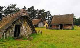
  West Stow. A Recreation of a Saxon village. This post will  (I hope)  complete my effort to track the changes in the landscape and population of this sceptred isle. In fact it isn't clear that the landscape changed much over the first few centuries after the Romans left. But for continuity I have to cover who it was that 'wasn't doing much'. In future posts, covering  the  Middle Ages and beyond,  I will adhere more strictly to the theme of the evolution of the landscape . These are the Dark Ages, not because they were particularly gloomy, but because we don't know much about them, filling the gaps by superimposing our current notions on how things are organised around kings, nations and regular armies. The reality was almost certainly more chaotic.  It  might be better to think of early England as being a bit like the Congo, with weak or non-existent central control and people with strong family and tribal loyalties. There would probably have b...

HIgh Chilterns and Horrible Henrys

Image
  GPX File of the Route :   High Chilterns & Horrible Henrys  This route covers some of the upland villages in the Southern Chilterns.It heads out of Goring using the Icknield Way and climbs along the open country on the east side of the Thames Valley and onwards to picturesque Ewelme. Thence onwards, ascending the Chiltern Hills circling clockwise past the manors of Stonor and Grey’s Court, then through Stoke Row on the return to Goring. It is almost entirely based on quiet and minor roads and although there are quite a few climbs, none are steep. For more detail see the Route Tips below. Zoom In Highlights are: Goring itself, check the view from the bridge. Views across the Goring Gap from the valley side. Historic Ewelme & Alice Chaucer Beautiful deciduous ‘ancient’ woodlands Stonor Park Grey’s Court, an Elizabethan Manor The Maharajah’s Well. Odd enough to get into Atlas Obscura! I confess...

Deep Past : Intro.

Image
This is an introduction to my 'Deep Past' Series. You have found it either on my bike routes website (pootler.co.uk) or my gallimaufry (oildrumlane.co.uk) My aim is to produce a brief, phone-friendly, jargon-free and high-level summary of the origin and nature of the general features of the landscape of this area, leaving finer detail to other posts.  This involves many compromises, so it  will be thin gruel. I have stuck to mainstream interpretations and explanations and  I cannot pose as an expert, but I have done some homework. If you can tell me how to improve this stuff without lengthening it, please do.  Note that the series is not a single linear narrative. I have diverted or disappeared down a rabbit hole where I think it adds to the the understanding of our area. Posts 1 - 5  take you from the creation (!) through to the arrival of humans. Posts 6 - 9  stretches to Feudal times with more about the inhabitants. Posts 10 - 13 look at the gradual crea...

The Goring Gap

Image
GPX file of the route  Goring Gap GPX This ‘figure of eight’ tour takes you from the wide, flat Thames Valley at the East end of the Vale of the White Horse, into much narrower and steep sides valley where the river cuts a course between the Chilterns meets the North Wessex Downs. This is the Goring Gap. It starts from Didcot station and heads north on NCR 5, a good(ish) cycle path towards the Thames, which it follows to Dorchester and Wallingford. Both were important cities in the Iron age and the Saxon period respectively and both can prove it!. It then continues along the bottom of the Goring Gap to Goring itself before returning to Wallingford, enjoying longer views from the upper side of the valley. From there it skirts the foot of the Downs back to Didcot. Apart from NCR 5 out of Didcot, It is mostly flat, minor roads with the odd busier stretch near the river. Much of it is flat, but there is a long but gentle climb out of Goring and an unmade section around South...