Posts

Oundle (Overnighter)

Image
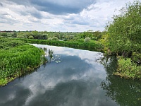
Nene Valley Path E of Rushden GPX File to Download      Bedford to Oundle Route This is a 73 mile circular route starting from Bedford Station. I chose to do it slowly, over two short days.  Heading out of Bedford, the fields are not far away and after you get to Rushden Green you are in rolling green countryside. The lunch stop was a great cafĂ© at Higham Ferrers on the west edge of Rushden, which felt more like a village than a suburb. From there the Nene Valley Way is a gravel track through the flooded gravel pit lakes to Thrapston which you bypass on the way to Oundle. I gather that Oundle has a reputation as being bourgeois to its bootstraps with a posh school at its heart,  this one with particularly hideous uniforms for the poor girls.    Lovely honey coloured stone throughout. Nearby, the Talbot Hotel is a carefully converted historic gem, but not ‘budget’. The bar and restaurant are OK but the even older ‘Ship’, a few doors down, has great bee...

A Hillfort Near You

Image
Hillforts pepper our hills, maybe around four thousand across the country. At least we  have called them hillforts. But are they? It seems that they not always on hills and probably not usually forts. The label was pinned on them by Sir Mortimer Wheeler, one of the most revered pre-history pundits of the 20th century and a former Brigadier in the Army so he might just have seen what he was programmed to see!  Sir Mortimer Wheeler Gandalf in the City?   In my own search for a sound basis for generalisation, I drew on lots of visits, slogged my way through a fat tome on hillforts generally, waded through archaeology papers in the British Library, scaled a mound of local landscape history books and tiptoed into the prehistory nerd websites. After all that, they remained inscrutable.  Some do seem to have seen conflicts. We are confident that Cadbury in Dorset saw battles with the Romans.  Others were clearly built with defence in mind, for instance by adding a...

Calleva and the Devil's Highway

Image
  GPX File of Route :   Calleva This is a tour of the Berkshire countryside which starts from Theale Station and ends up at Twyford Station, further down the line to Paddington. It links places in the valleys of the Kennet, Loddon and Blackwater rivers, starting off on the towpath of the canalised River Kennet (NCR 4) but after that follows minor roads through green, rolling mixed farming country to Aldermaston, Silchester and eastwards. The exception being a rather tedious stretch through Winnersh on the home straight.   Zoom In The standout attraction is Roman Silchester whose visible remains are, in my humble opinion, only bettered by Hadrian’s wall in the UK. There are also traces of the pre-Roman settlements here.  The bucolic Kennet towpath. The Duke of Wellington’s Estate at Stratfield Saye. (You need to pay to enter). A rather good Nature Reserve & Cafe at Dinton Pastures The odd oddity. On the debit si...

10 : From Britons to Saxons

Image
  West Stow. A Recreation of a Saxon village. This post  will  (I hope)  complete my effort to track the population of this sceptred isle. In future posts, I will turn back to the evolution of the landscape through the Middle Ages and beyond. These are the Dark Ages, so-called not because they were particularly gloomy, but because we don't much about them, filling the gaps by superimposing our current notions on how things are organized around kings, nations and regular armies. The reality was almost certainly more chaotic.  It  might be better to think of early England as being a bit like the Congo, with weak or non-existent central control, quite tribal with strong family loyalties, informal invasions, lots of refugees and the odd wandering, plundering warlord. It all started with what appears to have been the takeover of much of this part of the country by a consortium of tribes whose business plan was international expansion.  Procopius, a historia...

9 : Bronze and Iron

Image
The last post saw the rise and fall of the last of the neolithic populations of England. In the same way as they had replaced the earlier population, they in turn were replaced by lighter-skinned settlers originating from the Caucasian Steppe; people who used bronze tools and kept horses and cattle. The  changes on the ground were gradual but eventually profound, and the  region might have got its first blond, as well as one of the earliest flavours of the Indo-European group of languages which predominates today.  One of their villages has been unearthed in Norfolk and tells us a lot about them. See (Link)  Must Farm   I am not inclined to do a cycle tour thereabouts because while today's landscape is just too dull, but i f you are interested in pre-history you could also check out (Link)  Flag Fen where there is an exhibition of what has been found.  These people added the Sarsens to the already ancient monuments at Stonehenge, the King's Men to the ...