Posts

The Lambourn Valley & The Wessex Downs

Image
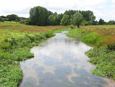
  Link to GPX File of the Route This ride takes you from Newbury into the green valley of the River Lambourn, a classic chalk stream, which starts near Lambourn village and joins the Kennet in Newbury. At Great Shefford it turns north and climbs towards the open, arable, upland of the North Wessex Downs. You then have a 7 mile roller coaster ride along the hilltops with great views, before returning downhill back to Newbury, passing through villages set in the more wooded terrain of the lower lower eastern slopes. This peaceful countryside has been settled for millennia and vestiges of the inhabitants and their farming, from the bronze age through medieval times to the Victorians, can still be found. It is all on roads which, outside of busy Newbury, are small and quiet. Highlights are: The watermills and (probably!) medieval water meadows of the Lambourn, a classic chalk country stream. Creating and maintaining these is more complicated than you might imagine. ...

Greenham & The Kennet

Image
  Link to GPX File of the Route This ride visits the Commons and woodlands that border the higher ground around the valleys of two tributaries of the Thames; the Pangbourne and Kennet Rivers. These Commons have been the staging ground of battles, riots and demonstrations for 400 years. Starting from Theale, it heads up to the Pang Valley which it follows on the south side before descending to meet the river at the pretty village of Bucklebury. It then heads south to Bucklebury Common. Descending again, you cross the River Kennet at Thatcham and head up towards Greenham Common, infamously used as a nuclear guest-house by US air base during the cold war. You then return to the Kennet via Newbury Racecourse, and follow its towpath for 12 miles back towards Theale. Highlights are: The sites of the 1980’s anti-nuclear protests at Greenham Common, now renewed and green again but not hiding the old bomb proof bunkers and control tower. Newbury Racecourse. A na...

Deep Past : Intro.

Image
This is an introduction to my 'Deep Past' Series. You have found it either on my bike routes website (pootler.co.uk) or my gallimaufry (oildrumlane.co.uk) My aim is to produce a brief, phone-friendly, jargon-free and high-level summary of the origin and nature of the general features of the landscape of this area, leaving finer detail to other posts.  This involves many compromises, so it  will be thin gruel. I have stuck to mainstream interpretations and explanations and  I cannot pose as an expert, but I have done some homework. If you can tell me how to improve this stuff without lengthening it, please do.  Note that the series is not a single linear narrative. I have diverted or disappeared down a rabbit hole where I think it adds to the the understanding of our area. Posts 1 - 5  take you from the creation (!) through to the arrival of humans. Posts 6 - 9  stretches to Feudal times with more about the inhabitants. Posts 10 - 13 look at the gradual crea...

Deep Past 5 . Chilling Out

Image
In previous posts I covered the rock foundations of our hills and valleys, so now I will torture the analogy and look at the floor coverings. T his 4th post in the series starts from around 2.5 million years ago  which, in geological terms, is a distance from the present day no greater than the gaps in a country  bus timetable.  Effectively this is the  ice ages and their legacy.  The debates about the constant and radical changes to the landscape and the climate over millions of years have always made it hard for a non-specialist like me, to sift out simple cause and effect relationships. Now, as get closer to the present, the increasing amount of fine-grained detail available makes it  even harder. So i f any professional paleogeologists are reading this,  stop now,  for the sake of your mental health.    At the point when we left the last post, what is now South East England was still connected to Europe.  The map below will giv...