Posts

Showing posts with the label Herts

Nasty, Romans & Vogons

Image
Link to the GPX File   Nasty, Romans & Vogons Why the comma in the title of this ride? Think 'Have you eaten Grandma'? The route starts from Knebworth Station and then runs clockwise to the east of Stevenage, on quiet, gently undulating roads around the East Hertfordshire Plateau. (You could as easily start from Stevenage, if you don’t mind the town traffic!). It crosses the River Rib and (Roman) Ermine Street at Buntingford and beyond that follows the River Quin south to Braughing, before turning West to return to Knebworth via Stapleford. The varied landscape is a microcosm of the changes in the agricultural and village landscape since Medieval times. Zooming In Highlights are: The post mill in Cromer. You won’t see many of those! Locations used in the 2005 film of 'Hitchhiker's Guide to the Galaxy, Arthur Dent's house and the local pub, where he is drinking when the planet is blown up. A hamlet named 'Nasty'. You c...

A Hillfort Near You

Image
Hillforts pepper our hills, maybe around four thousand across the country. At least we  have called them hillforts. But are they? It seems that they not always on hills and probably not usually forts. The label was pinned on them by Sir Mortimer Wheeler, one of the most revered pre-history pundits of the 20th century and a former Brigadier in the Army so he might just have seen what he was programmed to see!  Sir Mortimer Wheeler Gandalf in the City?   In my own search for a sound basis for generalisation, I drew on lots of visits, slogged my way through a fat tome on hillforts generally, waded through archaeology papers in the British Library, scaled a mound of local landscape history books and tiptoed into the prehistory nerd websites. After all that, they remained inscrutable.  Some do seem to have seen conflicts. We are confident that Cadbury in Dorset saw battles with the Romans.  Others were clearly built with defence in mind, for instance by adding a...

9 : From Britons to Saxons

Image
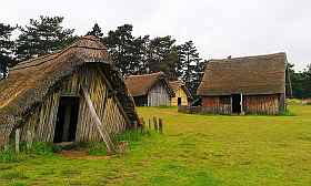
  West Stow. A Recreation of a Saxon village. This post will  (I hope)  complete my effort to track the changes in the landscape and population of this sceptred isle. In fact it isn't clear that the landscape changed much over the first few centuries after the Romans left. But for continuity I have to cover who it was that 'wasn't doing much'. In future posts, covering  the  Middle Ages and beyond,  I will adhere more strictly to the theme of the evolution of the landscape . These are the Dark Ages, not because they were particularly gloomy, but because we don't know much about them, filling the gaps by superimposing our current notions on how things are organised around kings, nations and regular armies. The reality was almost certainly more chaotic.  It  might be better to think of early England as being a bit like the Congo, with weak or non-existent central control and people with strong family and tribal loyalties. There would probably have b...

Deep Past : Intro.

Image
This is an introduction to my 'Deep Past' Series. You have found it either on my bike routes website (pootler.co.uk) or my gallimaufry (oildrumlane.co.uk) My aim is to produce a brief, phone-friendly, jargon-free and high-level summary of the origin and nature of the general features of the landscape of this area, leaving finer detail to other posts.  This involves many compromises, so it  will be thin gruel. I have stuck to mainstream interpretations and explanations and  I cannot pose as an expert, but I have done some homework. If you can tell me how to improve this stuff without lengthening it, please do.  Note that the series is not a single linear narrative. I have diverted or disappeared down a rabbit hole where I think it adds to the the understanding of our area. Posts 1 - 5  take you from the creation (!) through to the arrival of humans. Posts 6 - 9  stretches to Feudal times with more about the inhabitants. Posts 10 - 13 look at the gradual crea...

Giro de Lilley Bottom - 30 & 40 mile Versions

Image
  GPX file of the route     Giro De Lilley Bottom 30 & 40 mile version This is a tour of the varied and undulating countryside of the eastern Chilterns and the valleys of the Mimram and Lea Rivers. The route starts from Harpenden Railway Station and heads down to and across the valley of the River Lea. It then crosses the higher ground between the rivers, ducks under the Luton Airport flightpath, and descends into ‘Lilley Bottom’ for 3 miles. This is the valley of the River Mimram, but this usually only emerges on the surface to flow south, where you join the valley road and head north where the valley is dry. At this point the two routes diverge. The longer route, which probably doesn’t suit lightweight road bikes, takes you over the scarp and into the vale beyond before doubling back to Offley. It adds about 10 miles overall. The shorter route takes you straight to Offley. From there you have a meandering route back to Wheathampstead and then Harpenden. Zo...