Posts

Showing posts with the label Goring

HIgh Chilterns and Horrible Henrys

Image
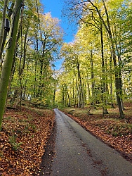
  GPX File of the Route :   High Chilterns & Horrible Henrys  This route covers some of the upland villages in the Southern Chilterns.It heads out of Goring using the Icknield Way and climbs along the open country on the east side of the Thames Valley and onwards to picturesque Ewelme. Thence onwards, ascending the Chiltern Hills circling clockwise past the manors of Stonor and Grey’s Court, then through Stoke Row on the return to Goring. It is almost entirely based on quiet and minor roads and although there are quite a few climbs, none are steep. For more detail see the Route Tips below. Zoom In Highlights are: Goring itself, check the view from the bridge. Views across the Goring Gap from the valley side. Historic Ewelme & Alice Chaucer Beautiful deciduous ‘ancient’ woodlands Stonor Park Grey’s Court, an Elizabethan Manor The Maharajah’s Well. Odd enough to get into Atlas Obscura! I confess...

The Goring Gap

Image
GPX file of the route  Goring Gap GPX This ‘figure of eight’ tour takes you from the wide, flat Thames Valley at the East end of the Vale of the White Horse, into much narrower and steep sides valley where the river cuts a course between the Chilterns meets the North Wessex Downs. This is the Goring Gap. It starts from Didcot station and heads north on NCR 5, a good(ish) cycle path towards the Thames, which it follows to Dorchester and Wallingford. Both were important cities in the Iron age and the Saxon period respectively and both can prove it!. It then continues along the bottom of the Goring Gap to Goring itself before returning to Wallingford, enjoying longer views from the upper side of the valley. From there it skirts the foot of the Downs back to Didcot. Apart from NCR 5 out of Didcot, It is mostly flat, minor roads with the odd busier stretch near the river. Much of it is flat, but there is a long but gentle climb out of Goring and an unmade section around South...