Posts

Showing posts with the label Ephemera

Start Here

Image
There are two pages here: 'The Routes’ is a list of the bike rides and explains how to use them.  ‘Other Stuff’  contains background notes on the landscape and history of the area as a whole.  This avoids my having to repeat the story in every set of route notes. The gallimaufry of irrelevancies on a wider range of topics can now be found here  at www.oildrumlane.co.uk The dictionary defines 'pootle’ as 'to move somewhere slowly and with no real purpose. This website is home for a collection of bike routes created with an eye for scenery, variety, interest and amusement, aimed at my fellow pootlers and slow cyclists. Most are 30- 40 miles long and either circular or start and finish on the same railway line out of a North London terminal. There are a few longer rides which I treat as overnight trips but which could be done in a long day by the super-fit or electric bike users. All are accompanied by detailed notes on the sights and places that I found ...

The Olde Country Cottage

Image
Country cottages. Warped ships' timbers, honeysuckle, pixie-cut thatched roof,  a misshapen chimney, the aroma of baking and  Vaughan Williams 'Pastoral' drifting out of the small paned window. Very twee.  Do you ever wonder whether they are really ancient or just more recent fakes?  This post is about the oldest, visible surviving rural housing used by the common people and in particular how much you can see from the road. It is impractical to include much detail in a post aimed at mobile phone readers so  I have added notes and links in a postscript i n case you want to peek behind the floral curtains and take a closer look,  It isn't easy. Timber was the common building material and it lasts well but the main survivors from medieval times are the stone buildings like churches and mansions which I am not concerned with here. There are few details, let alone complete houses, that have survived e xtensions, reconfigurations and improvements; and no clear...

3. Mud

Image
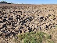
Our regional landscape has its origins in mud on the seabed, so at this point in our trudge through the stygian gloom of geological history, let us take a closer look at that mud, in all its various flavours, gloopy, crumbly and the various types of stone that it morphed into.  Apologia. The passively interested reader might find this the most stultifyingly tedious post on this blog, with  graphics that are awe-inspiringly uninspiring, even compared with the low standards I set.  It is here  for the sake of completeness and  because, worryingly, I think that mud has a story to tell. But you might find it helps you to doze off.    While tootling around the planet on its way toward its current position on the globe, South East England often found itself in a liminal zone between land and sea, sometimes one and sometimes the other, depending on the sea levels. What we see today is based on the compacted sediments of sand, gravel and biological detritus th...

4: The Chalk

Image
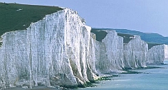
  Brass Point nr. Beachy Head I introduced the Chalk in my previous post.  The hills rolling downs of pure white stone surround London and the Thames Valley. A lot of this is 'ancient' country, the bleached clean bones of old England and  Tolkien's Barrow Downs.   Wonderful stuff.  There aren’t many places in the world where pure chalk rises to the surface, and England has most of it.  If you are walking, it is usually dry and springy underfoot and on a bike the slopes are merciful. Cretaceous Earth Its origins are described in the first two posts in my 'Deep Past' series; Links: ' From Hell to High Water '  and ' Coming Up For Air '.  A short reprise. The chalk was formed at the bottom of an ancient sea at  around the same latitude where you now find North Africa. Sharks swam in it, crabs scuttled along the bed and coiled carnivorous cephalopods called ammonites floated about.  At the bottom of the food chain, then as now, were clouds o...